...The National Weather Service in Indianapolis IN has issued a Flood Warning for the following river and location in Indiana... Wabash River at Montezuma. .Past and upcoming rainfall is expected to push the Wabash River above flood stage toward early to mid afternoon Monday at Montezuma in western Indiana. The current forecast calls for a crest of about four tenths of a foot above flood stage, and for the river to drop below flood stage May 1. PRECAUTIONARY/PREPAREDNESS ACTIONS... Caution is urged when walking near riverbanks. Be especially cautious at night when it is harder to recognize the dangers of flooding. Additional information is available at www.weather.gov/ind. The next statement should be issued Monday afternoon by around 200 PM EDT. && ...FLOOD WARNING IN EFFECT FROM MONDAY AFTERNOON TO EARLY THURSDAY MORNING... * WHAT...Minor flooding is forecast. * WHERE...Wabash River at Montezuma. * WHEN...From Monday afternoon to early Thursday morning. * IMPACTS...At 14.0 feet, Several hundred acres of bottomlands along the right bank from the mouth of Sugar Creek to northern edge of Montezuma begin to flood. * ADDITIONAL DETAILS... - At 8:45 PM EDT Sunday the stage was 13.2 feet. - Forecast...The river is expected to rise above flood stage tomorrow afternoon to a crest of 14.4 feet Tuesday morning. It will then fall below flood stage Wednesday afternoon. - Flood stage is 14.0 feet. - http://www.weather.gov/safety/flood &&
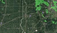
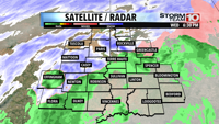
Currently in Terre Haute