 Ask DoTBot


Mandurah Ocean Marina cam
Access the live and archived images from the coast cam at Mandurah Ocean Marina.
The Mandurah Ocean Marina web cam is located on the roof of the Mandurah Marine Operation Centre in the Mandurah Ocean Marina. The camera faces in a westerly direction.
A new image is available every minute, you may need to refresh your browser to see the new image.
Mandurah Ocean Marina cam and archive
Use the arrow buttons beneath the image to view the image archive.


Go to time
Check other coastal conditions
View tides
View waves
Check Temporary Notices to Mariners
View the BOM Mandurah forecast below.
| Bureau of Meteorology (BOM): Mandurah forecast |
|---|
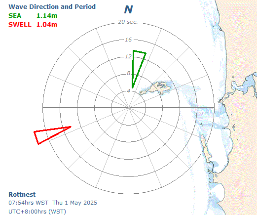
Rottnest Island sea and swell directional graph
The bearing of the arrow indicates the direction of the sea and swell. The point of the arrow indicates the peak energy wave period for both sea and swell.
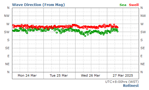
Rottnest Island historical wave direction graph
The coloured circles indicate the changes in sea and swell direction over time.
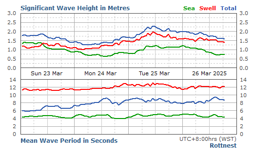
Rottnest Island significant wave height graph
The significant wave height is the average height of the highest one third of waves recorded. It is often the wave height reported by an experienced observer.
Coast cam disclaimer and conditions of use
Note:
Coast cam information is provided to the public subject to the Department of Transport's disclaimer, privacy, copyright and conditions of use policy.